The Heart of the Amalfi Coast – A divine mix of nature & culture – AMA2
Walking along the world's most beautiful coast, from Amalfi to Positano, with visits of Ravello and Capri
Amalfi e Atrani, Ravello, ‘Sentiero degli Dei’, Praiano e Positano (with Capri)
The Amalfi Coast is probably Italy’s most beautiful coastline. Moreover, the Costiera Amalfitana is located on the southern side of the Sorrento Peninsula, protected from the cold northern winds by its impressive mountains, and therefore has a wonderful climate all year long. Therefore this tour is a good option for a great walk already in early Spring or in late Autumn.
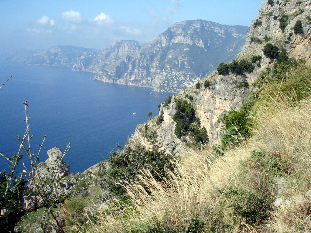
The landscape is immensely varied and surrounded by infinite ever changing views. It can be typical Mediterranean, intoxicated by wild perfumed herbs, with myrtle shrubs, thyme, rosemary and mastic trees, or almost alpine with meadows and bare rocks. And there’s cultural heritage abound! Man has created a stunning mosaic terraced landscape, which nothing can compare with.
And beautiful little churches, ruins of castles and old farmhouses are found all over… The Costiera Amalfitana is definitely Europe’s most dramatic stretch of coastline! And the best thing is, everything can be discovered on foot!
There are thousands of footpaths on the Amalfi coast, some which are famous such as the “Sentiero degli Dei” – the “Pathway of the Gods” – or are at least a thousand years old, like the “Maestra dei Villaggi” – the ‘main road’ of the medieval sea Republic of Amalfi. But also those less known are just as beautiful! Going from the sea to the mountains or vice versa, there are always stupendous views, and you’ll walk through little villages, vineyards and olive groves, Mediterranean scrubs and woods, living rocks and chestnut woods.
This walking tour can be considered the ’classic’ tour along the coast, which takes in all the famous coastal villages and the most beautiful walks to make in the area, some of which listed among the ‘world’s best walks’.
You’ll have the time to visit the villages which are a must to see: Amalfi itself, but also Atrani, wonderfully preserved through the centuries, Ravello with its magnificent villas, the quiet Praiano and of course the scenic and fashionable Positano.
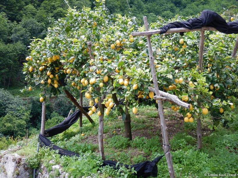
You will walk along well maintained footpaths, often paved alleyways, through attractive countryside, with wonderful terraced lemon groves, vineyards and cultural treasures like rural chapels, ancient farm houses, old water mills and wonderful villas and villages, where you can sit down and relax with a drink.
On this tour you will discover that with reason the Amalfi Coast has become Italy’s most famous coastline, but as well that it takes only a little effort to get ‘off the beaten track’, and that at only a few hundred metres away from the crowds, you will find yourself surrounded by nature.
Please note: this is a moderately easy tour which is suitable for those who have some experience with walking and a good general physical condition. Most of the walks are on good paths, some of them just recently restored by the local authorities. Part of the path is waymarked. Elsewhere it is necessary to follow the route notes provided together with the maps.
Average walking times: approx 5 to 6 hours each day.
Tour Highlights
- See Amalfi & Ravello, Praiano & Positano.
- Enjoy a special visit to the incredible Villa Cimbrone in Ravello.
- Enjoy spectacular but relatively easy walks, like the ‘Sentiero degli Dei’ (the ‘Path of the Gods’) & the ‘Valle dei Mulini’
- Stay in great hotels, in the heart of the famed villages of the Amalfi Coast

DAY–TO–DAY PROGRAMME
Day 1 – From Naples to Amalfi
Arrival in Naples (airport) or Salerno (train station). You are met by a taxi (optional) and brought to your hotel in Amalfi. Short visit to the town centre and maybe a swim to wash off the tiredness of the journey.
Hotel *** – Amalfi
Day 2 – The Torre dello Ziro & Valle dei Mulini
Today you make a first easy walk, which gives you immediately a good idea of the amazing cultural and natural heritage of the Amalfi Coast.
First you walk into the quiet little back alleys of Amalfi, where you still notice the strong Moorish influence. An ancient staircase takes you up underneath the impressive limestone cliffs, towards the little village of Pontone, part of the medieval defence system of the city of Amalfi.
The main point of interest is the marvellous Torre dello Zirro, located on a narrow ridge, in a park-like landscape, with unforgettable views of Amalfi to the one and Atrani to the other side. This area also offers a number of amazing picnic places, all with dramatic views. Then, through the charming village of Pontone itself, you walk into the ‘Valle dei Mulini’, the valley of the watermills, with the ruins of Europe’s most ancient paper mills, dating back to the 11th century.
The comfortable footpath runs along the river course, in an abundant green, almost un-Italian, landscape. Those who want can penetrate deep into the valley, through spectacular scenery, underneath the towering cliffs, through an almost fairy tale like landscape. Here you can admire a number of beautiful waterfalls. Then you return back down to Amalfi.
The path gradually descends along a number of impressive ruins of what once were the first paper mills, adding a mysterious touch to the landscape. Along the last stretch the scenery changes to lemon groves and maquis.
Back down in Amalfi you can pass at the paper museum, before returning to your hotel. As the walk is relatively short you now still have some time to wander around in Amalfi or take your time for a swim.
Hotel *** – Amalfi
Distance: 9 km. Approx. 4-5 h. walking. Ascent & descent: +/- 450 m.
Day 3 – Medieval Hamlets of the Amalfi Coast
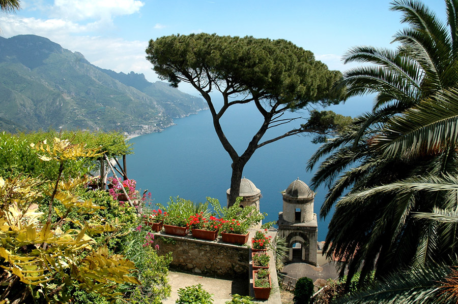
Today you walk along a beautiful route (or take the (open) bus) up to the charming historic village of Ravello, one of the most exclusive villages of the Amalfi Coast, and a sought after place by artists over the centuries, as its lofty position and sunny, dry climate made it an appealing place to writers, artists, musicians and travellers from northern Europe.
Boccaccio, DH Lawrence and Richard Wagner are among the more notable guests who have succumbed to its spells. Ravello not only has a very interesting history, and many medieval monuments, but also offers beautiful views over the Amalfi Coast.
The French novelist, André Gide, once described the town as being ‘closer to the sky than the seashore’. Ravello also boasts two magnificent villas – the superb 11th century Villa Rufolo, once a papal residence and later, the home of Wagner, and Villa Cimbrone, a sumptuous 19th century mansion with fabulous gardens and unequalled views over the Gulf of Salerno.
You can take your time to stroll through the village, before starting the walk back down to the coast. Along the dramatically located Villa Cimbrone and the hamlet of Castiglione you walk first through vineyards and lemon groves, then along a medieval flight of stairs down the beautiful little town of Atrani.
This certainly is one of the best preserved villages of the coast, with the possibility to look around the narrow white little streets of the town centre. The last short stretch to Amalfi is very scenic and has beautiful viewpoints on the city centre.
As the walk is relatively short you now still have some time to wander around in Amalfi or take your time for a swim.
Hotel *** – Amalfi
Distance: 9 km. Approx. 4 h. walking. Ascent & descent: +/- 480 m. (shorter options possible)
Day 4 – The “Via Maestra” to Praiano
From Amalfi you walk along one of the oldest pathways of the medieval Amalfi Maritime Republic, the ‘Maestra dei Villaggi’, or ‘main road of the villages’, an old paved mule track dating back to the 9th century.
You pass the little villages of Lone and Vettica, before arriving at the imposing monastery of Santa Rosa (there is also the possibility to take a local bus to here, avoiding a 300-m. ascent!). The walk from here first goes to the charming little village of Conca dei Marini, from where you’ll have wonderful views both on Amalfi and towards the western tip of the peninsula.
The route then descends to the coast again along some charming churches beautifully located above the rocky shore. You descend into the spectacular fjord of Furore, with its charming fishing village underneath the towering limestone cliffs.
From here you walk uphill again, and past the hamlet and church of Sant’Elia, you take the ‘Via dell’Amore’, into the Valley of Praia.
A great last stretch through forest, vineyards and Mediterranean scrubland, then brings you to the coastal village of Praiano, where you’ll stay for the next two nights. An optional descent to the very picturesque inlet of Marina di Praia, the old little harbor of Praiano, is worth the effort!
Hotel *** – Praiano
Distance: 11 km. Approx. 6 h. walking. Ascent & descent: + 700 m./- 500 m.
Day 5 – Into the Green Valley of Praia
From your hotel you walk through the little streets of Praiano, up towards the little church of Santa Maria di Costantinopoli. From here on a comfortable path above the village itself, you walk into the Valley of Praia, a beautiful green valley with many vineyards holding on to the cliffs.
You then climb up to the little church of Sant’Alfonso and from here the very scenic caves of Santa Barbara: another short section uphill brings you to the beginning of the famous ‘Sentiero degli Dei’ (Footpath of the Gods), a walk with unrivalled views.
After a very panoramic stretch with views over the whole Amalfi Coast, reaching out until the island of Capri, you start the descent back to Praiano again, passing over a centuries old staircase.
For those who still have some energy a descend to the little inlet ‘Cavitella’ is highly recommended.
Hotel *** – Praiano
Distance: 8 km. Approx. 5 h. walking. Ascent & descent: +/- 600 m.
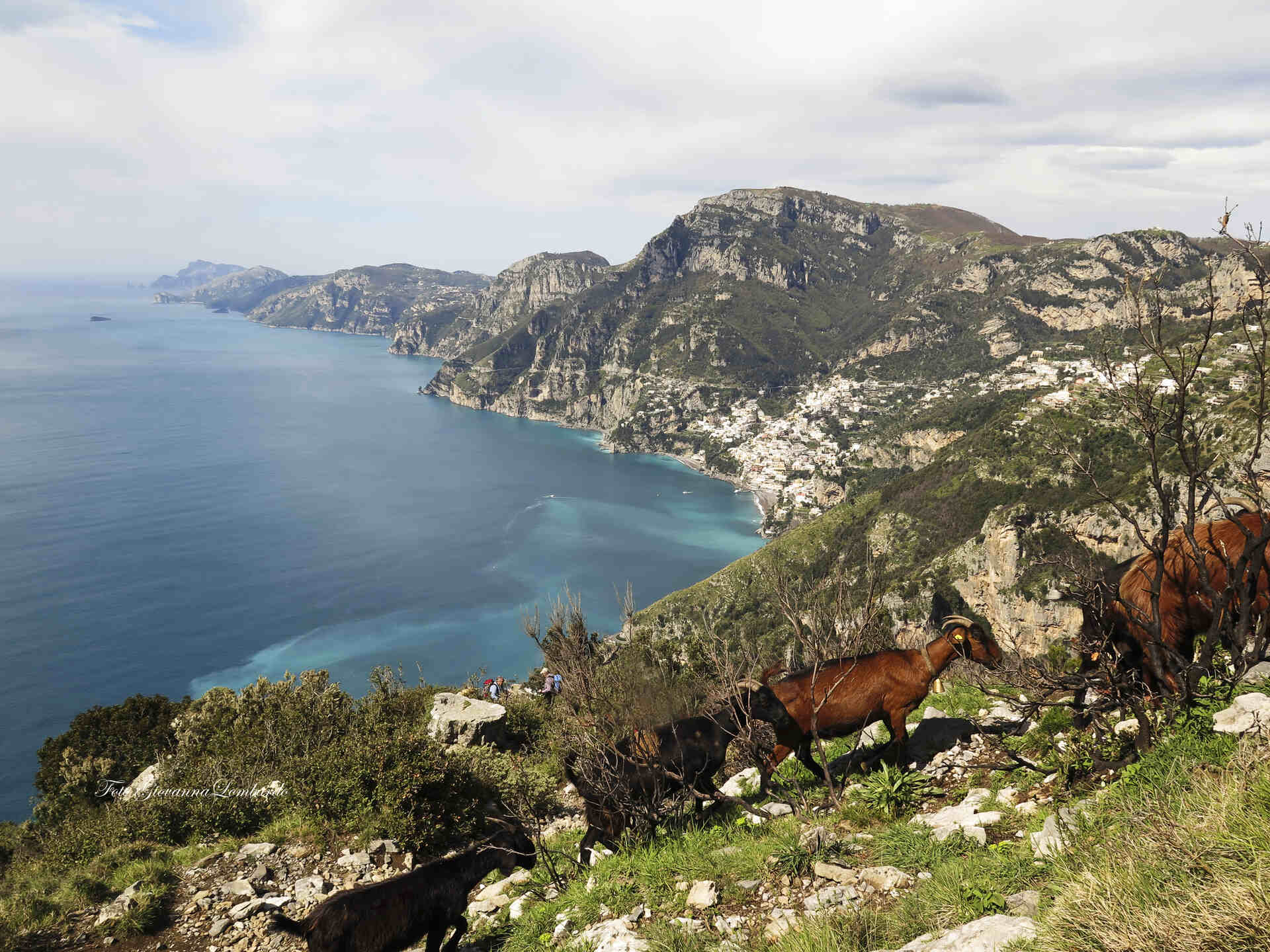
Day 6 – Along the “Path of the Gods” to Positano
You start your walk again in the picturesque white washed alleys of Praiano. Along a medieval pilgrims’ route you then walk uphill towards the monastery of San Domenico, set in a stupendous scenery, dominating the coast from its hilltop.
Here you can have a little rest before continuing the climb uphill, through spectacular scenery with bizarre rock formations and luxurious vegetation. Shortly you then reach one of Italy’s most famous footpaths, the ‘Sentiero degli Dei’, or ‘Footpath of the Gods’. This path really lives up to its name! Through unique scenery with unrivalled views you reach the hamlet of Nocelle.
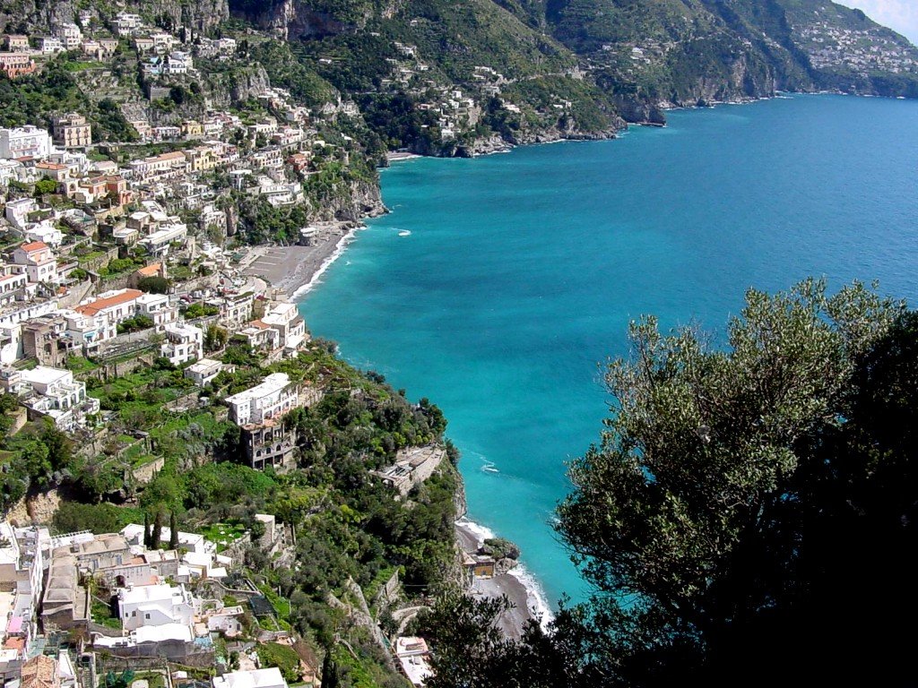
Passing another spectacular valley you arrive in the little village of Montepertuso. After Montepertuso it’s only a short walk downstairs to Positano, but it will take you some time as there are too many photo opportunities along the route.
Positano itself, is considered to be one of Italy’s most beautiful villages, and certainly one of the pearls of the Amalfi Coast. After a stroll through its alleys, you settle in your hotel in the centre, at walking distance from the large beach.
Hotel *** – Positano
Distance: 8,5 km. Approx. 4,5 h. walking. Ascent & descent: + 500 m./- 600 m.
Day 7 – Positano seen from above
Today you have two options: a stunning, utterly scenic hike high above Positano or a trip by boat to the rightly famous island of Capri, the island where already the Roman emperors liked to come as tourists, and that since then never lost its fame.
Of course here you will not only see the ‘touristy’ highlights, but you also make a beautiful round walk, passing the ruins of Villa Iovis, the most impressive Roman villa, the untouched coastline and many grottos. This walk can be extended or shortened in many ways, according to your wish to dedicate to walking, relaxing or shopping. In the late afternoon you then return by boat to Positano, along the ‘Islands of the Sirens’.
For the hike instead, you take the local bus up to Montepertuso, from where you start a very scenic walk, around the upper valley of Positano. Following ancient footpaths through the forest and along marvelous viewpoints you climb up towards Santa Maria al Castello, the old fortress defending the narrow valley between the Amalfi- and Sorrento-side of the peninsula.
From here you can admire both the Gulf of Salerno and the Bay of Naples. Through a nice wooded area in a park-like landscape you then descend to the Caserma Forestale (the forestry service’s house). For those who want there is the possibility to climb up from here to Monte Sant’Angelo, the highest mountain of the peninsula, a very demanding but rewarding ascent.
The standard walk though continues through the forest and zigzags back down to Montepertuso. Along another medieval mule track you then return to Positano again.
Hotel *** – Positano
Distance: 7 km. Approx. 4 h. walking. Ascent & descent:+ 350 m./- 550 m.
Day 8 – Departure
After breakfast you return by boat or bus and train to Naples and by shuttle bus to the airport. An extra night in a hotel can be booked upon request.
ACCOMMODATION & MEALS
All nights are spent in beautiful, characteristic family-run hotels (generally 3-star; UPGRADE 4/5-star on request). All rooms have en-suite facilities.
Accommodation is on B&B basis, in all accommodations. So no evening meals are included, and you are free to choose from the wide choice of restaurants in the area. Your accommodation holder can give you good tips. On some occasions you can also choose to eat at the premises of the hotel.
No picnic lunches are included in the tour price, but these can be prepared for you by the accommodation holders, or materials for picnics can be purchased in the villages where you stay. On some occasions you have the option to have your lunch in a restaurant along the way.
Nights 1, 2 & 3: The first three nights are spent at Amalfi, the ancient capital of the Amalfi Coast, in a welcoming and comfortable 3-star hotel. The hotel is centrally located at walking distance from the seashore and all main monuments of the medieval town center.
Nights 4 & 5: These nights you stay in the little town of Praiano, in a good 3-star hotel, with a few nice little beaches at walking distance. For those who want to relax a day longer, there’s the possibility to stay longer.
Nights 6 & 7: The last two nights are spent in the romantic & fashionable little village of Positano, with its characteristic houses built onto the steep slopes of the mountains. You stay in a comfortable 3-star hotel. The hotel is at walking distance from the seashore (along Positano’s charming little streets/stairs).
LEVEL OF DIFFICULTY
Moderately easy (2-3): Mostly easy walks, but with nonetheless some walking uphill, sometimes on paths with rough surfaces. On some days extensions or shortcuts are possible.
Fitness: High standard of fitness is not necessary but clients should be able to walk for up to 5 hours a day in hot sun on dusty or stony tracks.
FOOTPATHS & WAYMARKING
Footpaths: Most paths are relatively well maintained, but during the season some paths can get overgrown (we are in continuous contact with local authorities to keep the paths clean – please help us by providing your feedback on the quality of the paths).
Waymarking: Only a small part of the route is waymarked (partly by us); elsewhere it is necessary to follow the route descriptions provided together with the maps. With these it is always possible to find your route. In case you don’t feel confident a local guide can be provided for some trails.
INCLUSIONS
- 7 nights accommodation – BB
- 3 nights Hotel*** in Amalfi
- 2 nights Hotel*** in Praiano
- 2 nights Hotel*** in Positano
- Entrance ticket to the stunning Villa Cimbrone
- Extensive route notes, with description of the route & tourist information
- Maps at 1 : 25.000 scale
- Luggage transfer on day 4 & day 6
- 24/24 h local assistance
NOT INCLUDED
- Departure taxes
- Visas
- Travel Insurance
- Drinks and meals not mentioned in the itinerary
- Optional additional tours or activities
- Tips
- Items of personal nature
ARRIVAL & DEPARTURE
Arrival: The tour starts in AMALFI, connected with Salerno by a frequent bus (and boat) service and with Naples by a less frequent bus service. In Summer there are direct boats from Naples. A taxi pick-up service can be arranged either from Naples (airport or train station), or from Pompeii or Castellammare di Stabia, which can both be easily reached from Naples, with the local Circumvesuviana train.
Departure: The tour ends after breakfast on day 8 in POSITANO. A frequent bus service can bring you to either Sorrento or Amalfi/Salerno, from where you travel to your next destination (Naples, Salerno or Rome can all be easily reached). Several taxi services are available to bring you directly to your next destination.
EXTRA NIGHTS
It is possible to include extra nights in any of the accommodations en route. Extra walking or sightseeing options will be provided!
At the beginning or the end of the tour there is also an opportunity to visit Naples and/or Pompeii, or spend some time on the beach. The tour can easily be extended with a few days in Naples or on the island of Capri (see tour variations). Several good accommodations are available. Details and prices on request.
8 Days Prices
| trip season | tour price | single suppl. | solo traveller | ||
|---|---|---|---|---|---|
| 23 August – 30 September 2026* | € 1300 | € 750 | – – – | Reserve your place | |
| 01 October – 31 October 2026 | € 1050 | € 580 | – – – | Reserve your place | |
| 01 November 2026 – 19 March 2027 | – – – | – – – | – – – | contact us | |
| 20 March – 23 March 2027 | € 1080 | € 600 | – – – | Reserve your place | |
| 24 March – 30 April 2027 | € 1230 | € 690 | – – – | Reserve your place | |
| 01 May – 31 May 2027 | € 1320 | € 770 | – – – | Reserve your place | |
| 01 June – 31 July 2027* | € 1480 | € 870 | – – – | Reserve your place | |
| 01 August – 21 August 2027 | – – – | – – – | – – – | ||
| 22 August – 31 August 2027* | € 1560 | € 895 | – – – | Reserve your place | |
| 01 September – 30 September 2027 | € 1480 | € 870 | – – – | Reserve your place | |
| 01 October – 31 October 2027 | € 1190 | € 670 | – – – | Reserve your place |
*July & August departures: High temperatures expected. Good fitness and heat tolerance required.
Availability
& Conditions
| You can book this tour with a minimum of 1 person. | |
| There are a very limited number of available places on these dates. Immediate booking is recommended. | |
| Not available. | |
| Availability and prices on request. |
- Prices are per person and based on the season within which the first night of the tour falls.
- Prices are based on 2 people sharing double or twin accommodation. Single rooms (double rooms – single) are available on most trips however the supplements listed apply.
- If you are travelling alone then on some trips (which include taxi transfers) a ‘Solo Traveller Supplement’ will be applied instead of the normal single supplement.
- Prices are expressed in Euro’s. There will never be a currency surcharge.
- Actual exchange rates: GB £ – US $ – CAN $ – CHF – DKK – SEK – NOK – Other currencies.
‘PREMIER INN’ LUXURY VERSION
A luxury version of this tour is also available, with stays in the most authentic luxury hotels of the area. We can offer you a large selection of ‘Premiere Inns’, very good hotels, many among the world’s best hotels, as acclaimed from Condé Nast Traveler, Travel+Leisure and many others.
Genius Loci Travel, as the leading adventure travel company on the Amalfi Coast, can book your room in any hotel you could dream of!
SHORT ‘BEST WALKS’ VERSIONS
SHORT ‘BEST WALKS’ VERSIONS
In case you have only a few days available, but want to do some of the best walks we can recommend you the short break Best Walks of the Amalfi Coast – AMA2A.
Also do we offer short centre-based tours, staying in either Positano (the “Positano Best Walks”) or Amalfi (“Essential Amalfi”).
LONGER VERSIONS
In case you have more time available, we recommend you to book the longer, ‘complete’ 8-day version of this tour ‘The Heart of the Amalfi Coast’.
EXTENSIONS
EXPLORING CAPRI
Several hotels in Capri/Anacapri can be booked as an extension to your tour. There are direct boats from Positano to Capri. The program would then include two full day walks in Capri & Anacapri. For more details check out our Exploring Capri– short break.
N.B. Travelling in the morning by boat to the island of Capri, you can immediately start with the day walk of day two. Therefore to explore the island ‘in full’ you would need only two extra nights (while the full Capri tour includes three nights on the island).
To visit Capri only briefly it is also possible to book an extra night in Positano, as there is a direct boat from Positano to Capri. In that case you can make one beautiful round walk, passing the ruins of Villa Iovis, the most impressive roman villa, the untouched coastline and many grotto’s. This walk can be extended or shortened in many ways, according to your wish to dedicate to walking, relaxing or shopping. In the late afternoon you return by boat to Positano, along the ‘Islands of the Sirens’.
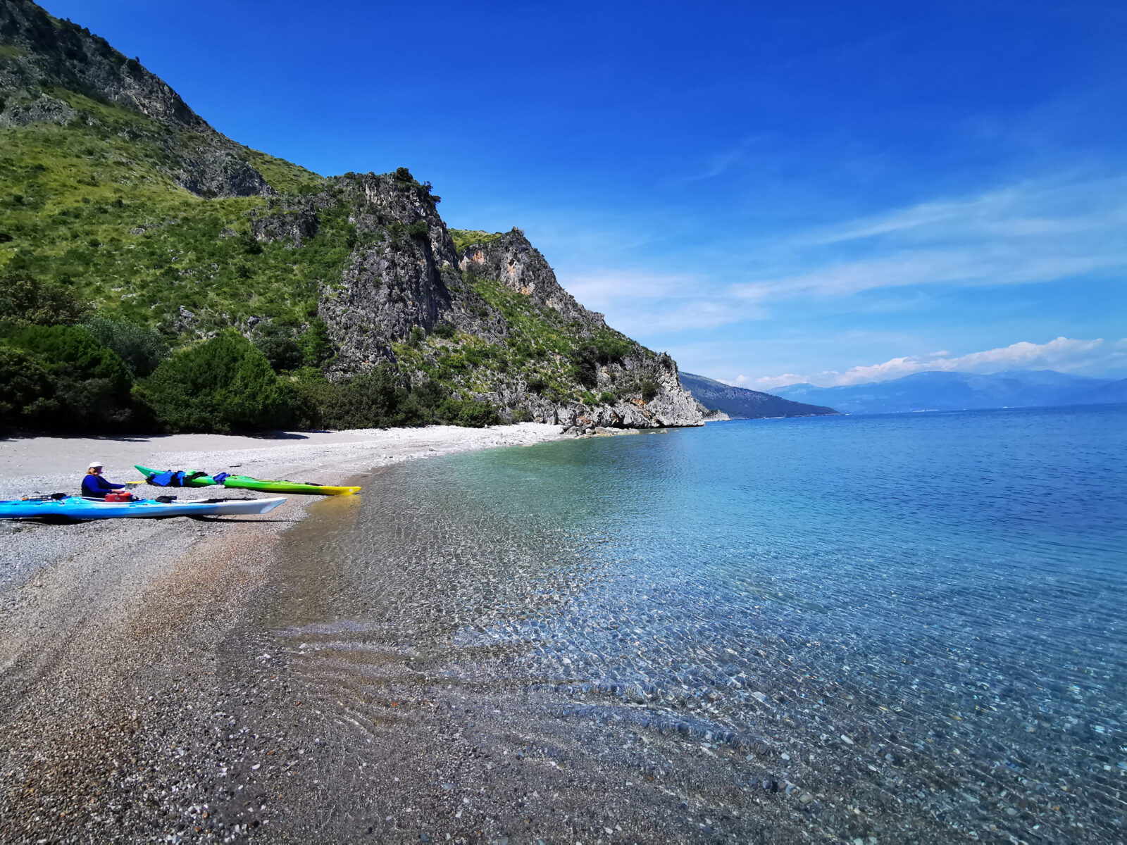
Possible extension: SEA KAYAKING
To explore the beauty of the Amalfi Coast, one of the best ways is definitely one foot. But there is another stunning way to explore the Amalfi Coast in a completely different way: by sea kayak.
From Positano you could opt to make a day trip to explore the many isolated beaches towards the west. Or you could opt to book a complete kayaking tour which brings you from Positano back to Amalfi, where you started your walking tour, enjoying the beauty of the Amalfi Coast in a completely different way.